One of the questions I’m often asked is “What is the metro like in London?”

First, there are several public transport systems in London, most of which are now managed by the city council. There is the London Underground, which Londoners call the “The Tube”, and it has 12 separate lines. The tube network is mainly in the north half of the city because of London’s geology. This system starts operating at around 5:30am and runs until about 12:30am seven days a week. The trains depart central London stations at about 2-3 minute intervals during peak times, and 7-8 minute intervals in off-peak times. Contrary to general opinion, much of the Tube is above ground, particularly away from the central zones. See the tube map.
There are also plenty of London buses, including the famous red double-deckers. Their routes extend across the whole of London and operate for similar hours to the tube. However, there are also night buses. These night buses run along similar routes to some of the day buses but have a reduced frequency. You can get on a night bus from about midnight in central London and take it to your neighbourhood in the suburbs.
Additionally, there are also river buses in central London, but they aren’t generally used by Londoners.
Finally, and definitely not least importantly, there is the National Rail network or over-ground train system. This is operated by many different companies and the trains depart from many central London terminus stations like Waterloo, King’s Cross, St Pancreas, Victoria and Paddington.
The southern half of London is mainly served by this overland network rather than the Tube. Therefore, if you look at the famous Tube map, don’t be fooled into thinking this is the complete ‘train’ network. There are in fact, probably, twice as many stations with the other 50% appearing on the ‘London Connections’ map.
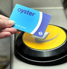
To use this network, you can buy single tickets to go from place to place, or you can buy daily, weekly or monthly tickets or even an oyster card from any of the stations or other points of sale such as newsagents. The cost of travel depends on how far you travel. The entire network is divided into 6 principal zones. These zones are arranged as concentric ‘circles’ around the centre of London. All you need to do is buy a ticket for the zones you want to travel to and from (and any zones you pass through en-route).
 To navigate on the Tube is very easy. Each line is colour coded. On the map, the stations where you can change from one line to another are shown as a circle, the non-interchange stations are shown as a ‘tag’. The direction of travel is shown on the front of each train and on signs on each platform. Additionally, it is important to know your north, south, east and west despite the fact that the platforms are labelled as northbound, southbound, eastbound or westbound. To find your way round, you simple follow the colours of the lines/signs and have a general idea if you need to go north or south.
I hope this brief introduction of getting about in London is helpful.
For further information: Transport for London
Pictures: Wikipedia and Guardian.co.ukUma das perguntas que sempre me fazem é “Como é o metrô em Londres?”

Para começar, há vários sistemas de transporte público em Londres, a maioria deles gerenciada pela prefeitura da cidade. Há o famoso metrô “London Underground”, que os londrinos chamam de “The Tube”, com 12 linhas separadas. A rede do Tube está localizada principalmente na parte norte da cidade devido à geologia de Londres. O sistema começa a operar às 5:30 da manhã e funciona até aproximadamente 00:30, sete dias por semana. Os trens partem das estações centrais de Londres a cada 2 ou 3 minutos durante os horários de pico, e em intervalos de 7 a 8 minutos nos outros horários. Ao contrário do que muitos pensam, grande parte do Tube não é subterrânea, principalmente nas áreas afastadas do centro da cidade. Veja o mapa do metrô.
Londres conta também com um sistema de ônibus: entre eles, os famosos double-deckers (ônibus de dois andares) vermelhos. As rotas se estendem por toda a cidade, e o horário de funcionamento é semelhante ao do metrô. A diferença é que existem os ônibus noturnos. Os ônibus noturnos mantêm rotas similares às de alguns ônibus diurnos, mas a frequência é menor. É possível pegar um ônibus noturno no centro de Londres a partir de meia-noite para ir aos bairros nos subúrbios.
Existem também ônibus-barco no centro de Londres, mas eles quase não são usados pelos londrinos.
E por último, mas com certeza não menos importante, há a Rede Nacional de ferrovias ou sistema de trens de superfície. Esses trens são operados por diferentes empresas e partem dos diversos terminais ferroviários de Londres como Waterloo, King’s Cross, St. Pancreas, Victoria e Paddington. A parte de Londres situada ao sul é servida principalmente por este sistema de trens de superfície e não pelo Tube. Sendo assim, não pense que a rede de “trens” que você vê no famoso mapa do metrô está completa. Na verdade, deve haver pelo menos o dobro de estações e essas outras 50% aparecem no mapa de conexões chamado “London Connections”.

Para usar todos esses tipos de transporte, você pode adquirir passagens únicas para ir de um lugar ao outro, ou pode adquirir passes diários, semanais ou mensais, ou o seu Oyster card. Eles podem ser comprados em qualquer estação ou outros pontos de venda como bancas de revistas. O custo da viagem depende da distância. A rede completa é divida em 6 zonas principais. Essas zonas são “círculos” concêntricos ao redor do centro de Londres. Você só precisa adquirir o bilhete válido para as zonas em que você quer se deslocar (e aquelas que estiverem no caminho).
É muito fácil usar o Tube. Cada linha tem uma cor diferente. No mapa, as estações em que você pode trocar de uma linha para outra são mostradas com um círculo, e as estações em que a troca não é possível não têm o círculo. O sentido da viagem é mostrado na frente de cada trem, e também aparece na plataforma. É importante saber em que sentido você quer ir (norte, sul, leste ou oeste), mas há indicação nas plataformas juntamente com os nomes das estações. Você verá “northbound” (para o norte), “southbound” (para o sul) “eastbound” (para o leste) ou “westbound” (para o oeste). Para achar seu trem, você deve seguir a cor ou o nome da linha que deseja tomar e saber mais ou menos se quer ir para o norte ou sul, leste ou oeste.
Espero que essa breve introdução ao transporte em Londres seja útil.
Fotos: Wikipedia e Guardian.co.uk

